(单词翻译:单击)
听力文本
Beginning, at the very beginning it was the third election of the United States
这是在美国建立后不久的美国的第三届大选
with J. Adams versus Thomas Jefferson and you can see in the electoral college
亚当斯和杰斐逊角逐总统,你可以看到选举团投票情况
How geographically structured it was
的地理分布
New England, some of the middle Atlantic states versus the south Pennsylvania
新英格兰地区,部分大西洋中部地区以及南宾夕法尼亚地区的州
Are In the middle of that swing position
投给了亚当斯
And we'll find many times in the American history when we have had geographical polarization
我们在美国历史上找到很多次这样的循环,地理分化在某个时期出现之后
And in other periods disappeared
又在某个时期消失
It both back and forth and new pattern emerged
在这样的重复往返中,新的地理划分模式出现
Very interesting way to look at the issue why red and blue?
这是个很有意思的问题,为什么常用红色和蓝色来表示两党呢?
Doesn't have to be
其实不一定的

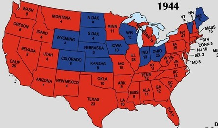
In fact, before 2000 it wasn't, it often wasn't different colors were used
在00年之前还没有形成这个习惯,不同的颜色都被使用过
sometimes blue was used for Republicans and red for Democrats as in this map in 1984
有的时候也会用蓝色表示共和党,红色表示民主党,正如这幅1984大选地图所示
and I should mention this wonderful Internet source
我要介绍一个非常好用的网络资源
Dave Leip's Atlas of U.S Presidential Election it's on the syllabus
Dave Leip的美国总统大选地图集,你们的课程摘要上也有写的
I would highly recommend that you spend sometime with it
我强烈推荐你们花点时间
you can even join in and get some extra goodness out of the site
访问一下这个网站,获取一些额外的信息
wonderful array of maps that Dave Leip has put together
上面有很多Dave leip合成的很好的地图
he started this before 2000 and he mapped it with Republicans as blue and Democrats as red
在2000年之前Dave Leip用蓝色表示共和党,红色表示民主党
people read it all the time saying it's confusing change it
读者们都说这看起来很容易让人混淆,改改吧
"I started doing it long time ago, why should I go back and change all of my maps"
Dave说我很久之前就开始制作这些地图了,难道要我把以前做的所有地图都改了?
well, for your benefit when I have use his maps I have made the change
不过为了让你们看得明白,我把我课堂上用的地图都改过来了(红为共和党蓝为民主党)
so otherwise, I think it would be a bit confusing
否则,我担心你们会觉得会很混乱
but actually in this fair election 1984,
但在这场1984年
Reagan vs Mondale David Brinkley on the nightly news
里根和蒙代尔之间的大选中,评论家大卫·布林克里在晚间新闻中
describe the Untied States the map of the Untied States as a sea of blue
把这幅反映美国选情的地图戏称为一片蓝色的海洋
by that he meant Republican voting pattern
也就是共和党赢得了大选
and you can certainly see at the county level oh, yes in deed, sea of blue
当我们把焦点放在县一级时,也的确是一片蓝色的海洋
even in the bay area you see as much blue as red there
即使是在旧金山湾区域,蓝色也和红色不相上下
and actually there were some people on the conservatives side of the political spectrum don't like the fact that
事实上很多政界中的保守派都不太喜欢
we now associate the Republican with red and the Democrats with blue
我们现在用红色表示共和党,用蓝色表示民主党
the argument being that red is the color of socialism shouldn't we put it other way around
有人说红色是代表社会主义的颜色,我们是不是该换个颜色呢?
Their had been arguments
虽然不少人对此有异议
but by in large the conservatives have made peace with it
不过大部分保守派人士还是忍受了这种做法
and actually you can find interesting blogs
事实上你可以在网上找到很多有趣的博客
like red state blog and whole number of different sites that embraced the term red state
例如红色州博客以及各种各样类似的网页,它们都接受红色代表支持共和党的做法
when we look at Canada, the map of Canada though however, we're finding still the convention is to put the conservatives with blue
如果你研究加拿大的大选地图,你会发现他们仍习惯于用蓝色来表示保守派
you can see how conservative Alberta is and liberals in various shades of reds
由此你可以看出艾伯塔省有多保守,自由派则用不同深浅的红色来表示
pink if they are not quite so strongly voting
例如,粉红色则表示其支持率不高
here we have the parti Quebecois in a sort of blue, green color
我们看到魁北克党是用蓝绿色来表示的
a little more complicated as far as its party structure goes
这是由它较为复杂的党组织结构决定的
视频及简介
本课程结合大量地图,探索了美国总统大选(包括过去和现在)中的地理学,并且对仅仅简单把美国分为红州(共和党)和蓝州(民主党)这一说法提出挑战。现实中,美国社会两党的情况,远比这种简单的两分法要复杂。


