(单词翻译:单击)

Science and Technology Seismology and tsunamis Making waves
科技 地震学与海啸 掀起新浪潮
A better tsunami-prediction system is now under development
更精准的海啸预测系统现已在开发中
GEOLOGISTS have long known that some marine earthquakes generate fierce tsunamis and some do not. But, as the situation in Japan makes painfully clear, there is no good way for people being tossed around by a tremor to know the difference until a wave arrives. A new earthquake-monitoring system developed by Andrew Newman and Jaime Convers at the Georgia Institute of Technology may, however, help to change that.
地质学家们早已知道有的海洋地震会引起强烈海啸,而有的则不会。但是,日本的惨痛教训告诉我们,被地震震得惊慌失控的人们根本意识不到一场海啸即将到来(在海啸到来之前,被地震震得惊惶失措的人们对此一无所知。)。而现在,由乔治亚理工学院的安德鲁?纽曼与亚伊梅?康弗斯共同研发的最新地震监测系统有望改变现状。
During an earthquake, the Earth's crust is uplifted. If the epicentre is on the seabed, that also lifts the water above the bed, creating a wave. However, the size of this wave varies with the nature of the uplift.
地震时,地壳板块隆升。如果震中位于海底,板块运动带动上方海水起伏,形成波浪。波浪大小因板块隆升性质而定。
For tsunami-generating purposes, earthquakes can generally be divided into two sorts. Deep ones (as a rule of thumb, those below 20km, or 12 miles) generate small or non-existent tsunamis because their uplifting effects are absorbed by the overburden. Shallow ones (above 20km), whose full crust-displacing force is felt at the surface, are the danger. The problem is deciding which is which. Once all the data are in, an earthquake's depth can be worked out with reasonable accuracy. But that takes time. The recent Japanese quake, for example, was thought initially to have happened 83km down. The latest measurements suggests its depth was actually 30km. Normally, that would still put it in the class of safe earthquakes, but it was so powerful that the usual rules did not apply.
按照是否引发海啸,地震可分两类。一是深震(一般在20km或12英里以下),隆升通常被表层所吸收,因此不引发海啸或只引发小型海啸。二是浅震(20km以上),由于地表震感强烈,因此也更危险。当前的问题是如何区分这两者。只要有全面的数据,则可较精准地测算地震的深度。然而,这一过程需花费一定时间。例如,近期日本地震最初深度测算为地下83km,而最近的一次测算结果却显示,深度实为30km。通常来说,30km仍可划入安全等级。但此次地震能量巨大,以往的经验概不管用。
The secret of the new method is that depth changes an earthquake's character in ways other than just its tsunami-generating propensity. The rupture in the rock that causes a deep earthquake propagates rapidly—at about 3km a second. A shallow rupture moves more slowly: 1?km a second is common. The speed seems related to the rigidity of the rock that is rupturing, and deep rock, which is under more pressure, is more rigid. Shallow rocks bend, and that slows the rupture down. The effect is to give seismologists a tool they can use to make an instant estimate of an earthquake's depth and thus, if it is submarine, the risk of its creating a big tsunami.
新系统的秘密在于地震深度对地震性质的改变不仅仅停留在是否引发海啸的问题上。岩层断裂引发深震传播速度很快——大约3km/秒。而浅震传播速度较慢:一般约1.5km/秒。速度可能与断裂岩层的坚硬程度有关,深层岩体受压力更大,也更坚硬。浅层岩体有韧度,可减缓断裂。地震学家可据此迅速估算地震深度,如果是海洋地震,还能估算地震是否引发强烈海啸。
The system Dr Newman and Mr Convers have developed taps into hundreds of seismic monitoring stations around the world. When an earthquake is detected, the software immediately looks at the size of the tremor and the location of its epicentre. If the quake's magnitude is greater than 6.5 and the epicentre is underwater, it then requests information from the relevant stations on how long the earthquake took from beginning to end. That allows it to work out how quickly energy was released by the earthquake, and thus how fast the rupture propagated. An energy-release rate indicating a rupture rate of 1?km a second or less sets the alarm bells ringing, for the earthquake has probably spawned a tsunami—though the system is also sensitive to the actual earthquake magnitude, and adjusts accordingly, so it did not miss the tsunami-creating potential of the Japanese earthquake either.
纽曼博士与康弗斯先生研发的新系统接入了世界各地几百所地震监测站。当检测到地震时,该系统软件立即测算地震规模与震中位置。如果级数超过6.5级且震中位于水下,系统则要求相关监测站报送地震全程持续时间。这一信息可帮助计算地震能量释放速度,并以此计算岩层断裂速度。岩层断裂速度达1.5km/秒以下的能量释放速度将会拉响警报,而这时极有可能引发海啸——尽管如此,该系统也能检测出地震级数并作出相应调整,因此也检测出了日本地震会引发海啸的风险。
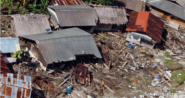
The two researchers tried their invention out last year and analysed a great many quakes, including one of magnitude 7.8 that happened on October 25th in western Indonesia. The epicentre was 70km from the Mentawai islands, and the quake was felt there only weakly. But it still raised a devastating tsunami (see picture above) that killed more than 400 islanders.
两位研究者去年对该发明进行了测试,用以分析了许多地震,包括去年10月25日印尼西部发生的里氏7.8级地震。震中位于距民大威群岛70km处,岛上只有轻微震感。但是,地震随后引发了一次破坏力极强的海啸(见上图),导致400多位岛民死亡。
The system quickly detected this quake and the two researchers reported recently in Geophysical Research Letters that it automatically identified the tsunami threat 8? minutes after the earthquake began. It then ran a series of checks, and after 16? minutes was completely certain that conditions were right for a tsunami to form. Since it took 35 minutes for the tsunami to come ashore, the system could, had it been used to sound the alarm, have given people 18? minutes to flee. Unfortunately, it was not then attached to any sort of alarm that could let the Mentawai islanders know that they were in danger.
该系统迅速检测到印尼地震,两位研究者近期在向《地理物理研究快报》的报告中指出,系统在地震开始后8.5分钟自动检测到震后海啸威胁。随后,系统启动了一系列检查程序,震后16.5分钟便完全确定海啸即将发生。因为海啸将在震后35分钟后到达,如果使用该系统发出警报,则为人们赢得了18.5分钟宝贵的逃生时间。不幸的是,该系统当时还未与警报系统结合,因此无法及时通知民大威群岛岛民海啸险情。
With luck, such a lack of warning will not happen again. By the summer the system should be hooked up to alarms around the world, and will be able to determine tsunami risk within seven minutes of a shock being detected. It will then be up to local authorities to have evacuation plans in place. But they will no longer be able to say they did not see it coming.
而幸运的是,缺乏警报机制的这种情况以后不会再有了。今年夏天之前,该系统将会与全世界警报系统相连接,并将会在检测到地震后7分钟内确定海啸发生的概率。随后则由地方政府开展撤离计划。到那时,政府便不可能再推脱说不知道海啸会来了。


