(单词翻译:单击)
听力文本
So we can see this is pretty much the same map, New Mexico sort of a bit out of the pattern but as I said before New Mexico very much a swing state
这两幅图看起来极为相似,除了新墨西哥看起来有点另类,但我说过了新墨西哥是个摇摆州
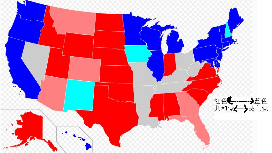
And what if we go back to Clinton second election against Dole
我们来看看克林顿的第二次大选,他的竞争对手是多尔
We don't' see the same pattern here at all, do we?
红蓝分布完全不一样,对吗?
We see a real swath in the middle of the country from Louisiana and Arkansas, including Tennessee, Kentucky
我们在中部看到一个狭长区域,从路易斯安那至阿肯色,再到田纳西和肯塔基
Voting for the Democratic camp and of course the Democratic candidate for the presidency and the vice-presidency were both southerners
他们都选了民主党阵营,一方面是因为民主党的总统和副总统候选人,都是南方人
And that is something that a lot of Democratic party strategist will say
对此很多民主党战略家都认为
It is important, maybe even necessary to win in how to get southerner who has a sort of reputation as a somewhat moderate individual
赢得南方有声望的温和派人士的支持是非常重要甚至必要的
And it certainly work to build Clinton in advantage
克林顿在这方面显然做得很出色
So you can see Clinton losing the southeast but winning in a lot of sort of south central area
所以克林顿虽在东南部落败但却在一些中南部的州获胜
Winning the very important state, Florida
赢得了非常关键的佛罗里达州的选票

You can see Indiana being a bit of exception in the mid west(east), and you can see a larger Pacific Democratic voting area, including Arizona state that doesn't go Democratic very often
中东部只有印第安纳州另类地支持共和党,至于太平洋沿岸则都是民主党的天下,包括亚利桑那州,它支持民主党的情况并不常见
Go back a little bit more, back 20 years to 1988 George Bush Senior against Michael Dukakis
再往回看,回到20年前,1988年老布什和杜卡基斯的那场大选
And what do we find here? we find a lot of states we now think of solidly blue solidly Democratic voting
我们发现了什么?我们发现很多现在泛蓝的十分坚定的民主党支持州
Like Vermont or Connecticut, New Jersey, Maryland, California then voting Republican. So there has been a real change
如佛蒙特,康涅狄格,新泽西,马里兰以及加州当时都把支持共和党,可见红蓝分布发生了很大的变换
We'll see this later on. we'll look at California county maps
稍后我们会细讲。我们分析加州的县级地图
By 1988 the bay area was mostly voting the Democrats, to be sure
88年时旧金山湾周围的县大多支持民主党,这是可以肯定的
But we go back another 10 year earlier, We'll find places like Glenn county San Mateo county voting for the Republican candidate
但再往前追溯10年,我们会发现格伦县,圣马特奥县,都支持共和党候选人
And actually at the same time, we'll find counties like Kern county voting for the Democrat,It's been a reversal in California, really interesting one.
同时你还会发现克恩县当时支持的是民主党,而今加州的情况完全相反,很有意思
That's something we can talk about, how much is that have to do with these areas changing their population? How much have to do with the political parities changing their orientations
这个问题值得我们思考,这与这些地区的人口变化有何关系?与政党的执政方针的变化有何关系?
视频及简介
本课程结合大量地图,探索了美国总统大选(包括过去和现在)中的地理学,并且对仅仅简单把美国分为红州(共和党)和蓝州(民主党)这一说法提出挑战。现实中,美国社会两党的情况,远比这种简单的两分法要复杂。


