(单词翻译:单击)
听力文本
JUDY WOODRUFF: The Gulf Coast is facing a very rough week. Tropical Storm Laura is gaining strength and could be a Category 3 hurricane by the time it makes landfall later this week. It's expected to hit along the coast of Louisiana and Texas, potentially with 100-plus-per-mile hour winds. And, even as we speak, the coast is feeling the effects of Tropical Storm Marco. It's weakened, but is still bringing rain. Ken Graham is the director of the National Hurricane Center. And he joins me now from Miami. Ken Graham, give us a sense of what these storms look like right now.
KEN GRAHAM, Director, National Hurricane Center: Yes, right now, looking at the satellite here, Marco is very close to making landfall right here at the mouth of the Mississippi River. But what is interesting is, most of the rain was sheered off. So, most of the heavy rain is the Southeast U.S. in the Florida Panhandle all the way up into Alabama, Georgia and Carolinas, so heavy rainfall, but we're looking at Laura as well, just a large circulation just south of the island of Cuba. And we expect it to make its way into the Gulf of Mexico and strengthen into a hurricane.
JUDY WOODRUFF: And, Ken Graham, how usual or not is it for two hurricanes…or two storms to be coming so close together like this?
KEN GRAHAM: Yes, it's just…it's very unusual. And it is a situation that it is usual from a meteorological perspective, but it's also unusual and difficult from a preparedness standpoint as well, because you start getting the impacts in certain locations from Marco, and, two days later, you start getting a stronger system. We expect to be a much stronger hurricane when it comes to Laura making its way to the Gulf Coast.
JUDY WOODRUFF: So, how does the first storm, which…as you say, Marco is weakening, but still bringing a lot of rain. How does that affect, complicate or lay the groundwork for the storm that follows it?

KEN GRAHAM: Yes, it's an interesting situation, because that storm was so small, so there wasn't much influence on the temperatures in the Gulf. There wasn't much influence really shaping how Laura reacts as well. So, this is what is going to happen. With time, we get into the Gulf, there is not a lot of sheer. The warm waters of the Gulf, the upper air pattern, everything's coming together for development. Expect that hurricane to make its way north toward the upper Texas coast, to Central Louisiana, get that landfall, however, a larger storm than Marco. So, some of those impacts can stretch well away from the center. You could you see storm surge as far away as the Mississippi coast, maybe even into Alabama, with that landfall even that far west.
JUDY WOODRUFF: And do you fell at this point, Ken Graham, the word is getting out sufficiently to people who could…could be affected by this?
KEN GRAHAM: Yes, we're doing every media interview that we can to get the information out. We're doing briefings. I'm actually out here in operations right now. The hurricane specialists are here on the phone doing briefings. We're doing everything we can to get the word out. But we really need to, because, if you think about it, the arrival of these impacts occur before the center. So, even you start looking at a center that is still in the Gulf, that storm surge, the rain, the wind is well out ahead. So you have today, you have tomorrow, and then all of a sudden, Wednesday, some of these impacts will be felt.
JUDY WOODRUFF: And that is what I wanted to ask you. When…what day are we looking at for maximum impact? You're looking at Wednesday?
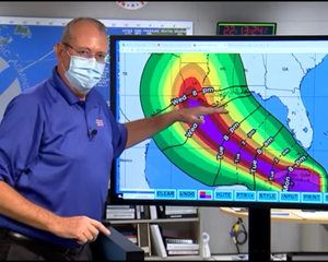
KEN GRAHAM: Yes, it looks like Wednesday. So, you see the landfall here. And I wanted to show this here. You start looking at the arrival of the winds, this is actually the arrival of the tropical-storm-force winds. That is a good indicator when you have got to wrap stuff up because it is too dangerous to be outside. So, Wednesday 8:00 a.m., you start seeing some of these winds reach the Southeast Louisiana coastline and during the day Wednesday spread northward. So, Wednesday, you are going to start seeing a whole lot of impacts along the Gulf Coast.
JUDY WOODRUFF: Ken Graham, director of the National Hurricane Center, thank you so much. We appreciate it.
KEN GRAHAM: Thank you.
重点解析
1.be close to 接近于……
This is a company that's handled risk very poorly at a time when risk is close to an all-time high.
这是一家在市场风险接近历史高点时极其不善于应对风险的公司。
2.sheer off 转向;避开,离开
The boat was able to sheer off in time to avoid an accident.
那船及时地躲开,避免了一场事故。
3.lay the groundwork 奠定基础
Yesterday's meeting was to lay the groundwork for the task ahead.
昨天的会议为后面的任务打下了基础。
4.with time 随时间的推移
Mars and Earth have orbits which change with time.
火星和地球的轨道随着时间而发生改变。
5.get the word out 散布信息
Manufacturers tend to rely on the media to get the word out.
生产厂家倾向于依靠媒体来传达信息。
参考译文
朱迪·伍德乐夫:墨西哥湾沿岸将面临非常严峻的一周,热带风暴劳拉的风力正在增强,在本周晚些时候登陆时可能会变成3级飓风。飓风预计将袭击路易斯安那州和德克萨斯州海岸,风速可能会达到每小时100多英里。而在我们说话的同时,海岸正遭受热带风暴马可的冲击,虽然风力已经减弱,但仍伴随降雨。肯·格雷厄姆是国家飓风中心的主任,现在他在迈阿密和我连线。肯·格雷厄姆,可以给我们说一下风暴目前的情况吗?
肯·格雷厄姆,国家飓风中心主任:好的,现在,看一下这边的卫星,马可很有可能在密西西比河的河口登陆。但有趣的是,大部分降雨被转移了。所以,暴雨的降雨地区主要在美国东南部的佛罗里达州,一直到亚拉巴马州、乔治亚州和卡罗来纳州,非常强的降雨。但我们同时也看到了劳拉,就是古巴岛南部的一个大型环流,我们预计它将进入墨西哥湾并变强成为飓风。
朱迪·伍德乐夫:肯·格雷厄姆,两场飓风、或者说两场风暴像这样离得这么近,这种情况常见吗?
肯·格雷厄姆:嗯,很罕见。从气象角度来看这种情况很常见,但从防范的角度来看这种情况很罕见、很棘手。因为刚开始只有特定的地方会受到马可的冲击,而两天后我们将看到一个更强大的系统。我们预计劳拉将会是一场更强的飓风,它正在向墨西哥湾沿岸移动。
朱迪·伍德乐夫:那么,第一场风暴的情况如何?就像你所说,马可正在减弱,但仍带来大量降雨。这将如何影响、复杂化或为之后的风暴奠定基础?
肯·格雷厄姆:是的,情况比较有意思,因为风暴马可很小,所以它对墨西哥湾的温度没有太大影响,它对风暴劳拉的大小影响也不大。但将要发生的情况是,随着时间的推移,风暴进入海湾,而那里峭壁较少,墨西哥湾温暖的海水、高空气流这些将赶在一起上升。飓风预计将向北边的德州北部海岸移动,之后在路易斯安那州的中部登陆。不过,这场风暴比马可要强,所以风暴的冲击可能会扩散至离风暴中心很远的地方,我们可以看到风暴潮远至密西西比海岸,甚至可能到达阿拉巴马州,甚至在更远的西部登陆。
朱迪·伍德乐夫:你是否觉得,肯·格雷厄姆,那些可能会受到影响的人已经完全熟知了这一消息?
肯·格雷厄姆:是的,我们正在尽一切可能接受媒体采访以散播这一信息。我们正在做简报,我其实现在就在这里操作这些事情,飓风专家在这里通过电话做简报,我们正尽一切努力把这一消息传出去。这些是我们需要做的,因为如果你仔细想想,这些冲击的到来发生在中心之前,所以,即使你开始观察一个仍在海湾的风暴中心,风暴潮,暴雨,狂风都在前方,所以今天没事,明天没事,然后突然到了星期三,你就能感受到冲击了。
朱迪·伍德乐夫:这就是我想问你的,什么时候……哪一天受到的冲击会最大?你的意思是星期三吗?
肯·格雷厄姆:是的,貌似就是星期三。所以,你看登陆在这里,我给你展示一下,刚开始我们会看到风刮过来,这其实是热带风暴级的风,这很好地提醒了我们要把东西包起来,因为外面很危险。所以,周三早上8点我们会开始看到风到达了路易斯安那州东南部的海岸线并在周三的白天向北扩散,所以在周三我们会开始看到整个墨西哥湾沿岸受到冲击。
朱迪·伍德乐夫:国家飓风中心主任肯·格雷厄姆,非常感谢您,谢谢。
肯·格雷厄姆:谢谢。
译文为可可英语翻译,未经授权请勿转载!


