(单词翻译:单击)
听力文本
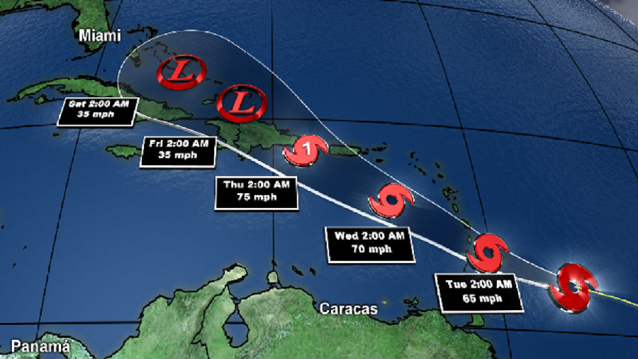
JUDY WOODRUFF: Hurricane Dorian is threatening to bear down on Florida by Monday, prompting residents there to start stocking up on bottled water, gas and other supplies. But the Category 1 hurricane's precise path is hard to predict. Dorian veered towards the Virgin Islands, drenching them with heavy rain and whipping winds, but then largely missed Puerto Rico. Ken Graham is the director of the National Hurricane Center in Miami, and he joins us now for an update. Ken Graham, welcome back to the NewsHour. First of all, tell us what you know right now about Dorian.
KEN GRAHAM, Director, National Hurricane Center: Every indication is continuing to get stronger. We're looking at this structure very closely, getting aircraft out there, studying this 24 hours a day. And getting stronger is exactly what we're forecasting, continuing to get stronger with time, just a lot of warm water, not a lot of shear, and then not a lot of interaction with terrain as well. So it's going to keep getting stronger. And we're forecasting to become a major hurricane,even a Category 4-strength, 130 miles an hour, as we approach the Florida coast, so a big event, a lot of uncertainty in the forecast. That center could be anywhere in that cone.
JUDY WOODRUFF: And, Ken, you say a lot of uncertainty. What is going to determine the exact path and the strength of this storm?

KEN GRAHAM: Yes, so many factors going on here. In this case, we have, this ridge of high pressure.It's out here. It almost acts like a bubble. So, when the storm moves forward, it hits that bubble. So the stronger that high pressure is, then we're going to have a quicker turn. If it's a little weaker, it's going to be wait a little bit longer. And that will be the northern track. So we're really trying to understand how strong that is. And that's why we're seeing the models change a little bit. And that's why we have a comb, because, with that uncertainty, it could be anywhere in there. So the message is anyone along the in Florida, along the coast, and also inland has to be ready.
JUDY WOODRUFF: Do you have a sense of when we're going to know better where it's hitting?
KEN GRAHAM: You know, I think really when we start seeing that turn. I think this is one of those situations that, as we move towards the northwest, we start seeing that turn more towards the west. I think, if you think about, with time after that happens, you can extrapolate from there, and that, we're going to have a better idea. So, in the next few days, I think we will have a better handle on it. But either way, no matter where that track goes, no matter where the center is, Florida will be impacted by rain, storm surge, the winds, just a big impact event.
JUDY WOODRUFF: So the advice then to people who live anywhere in that bubble area you have at the end is to do what?
KEN GRAHAM: It is to be ready, because, if you think about it, it's interesting. We have plotted the arrival of the tropical-storm-force winds. So, no matter the exact track, no matter where the center is, you will start seeing tropical-storm-force winds reach the coastline, here's Florida, probably late on Sunday, by 8:00 p.m. or so moving onshore.
So the winds are coming. The rain is coming. The storm surge is coming. So it's time to be prepared and listen for the latest information, and especially listen to those local officials.
JUDY WOODRUFF: Well, we will certainly do everything we can to get the word out.Ken Graham with the National Hurricane Center, thank you.
KEN GRAHAM: You bet.
重点解析
1.listen for 倾听
We listen for footsteps approaching
我们留神听是不是有脚步声传来。
2.at the end 最终
This point is developed further at the end of this chapter
这一点在本章结尾处有进一步阐释。
3.interaction with 互动
The following excerpt is illustrative of her interaction with students.
接下来的节选部分可以说明她与学生的互动情况。
4.stock up on 囤积
The authorities have urged people to stock up on fuel in case hostilities break out.
当局已敦促人们储存燃料,以防战事爆发。
5.prepared for 准备
The city's bomb shelters were being prepared for possible air raids.
为防御可能发生的空袭,该城市正在建防空洞。
参考译文
朱迪·伍德拉夫:飓风多里安预计周一就会逼近佛罗里达州,迫使那里的居民现在已经开始储备瓶装水、天然气和其他应急物资了。但是这股一级飓风的确切运动路径很难预测。多里安此前已经转向维尔京群岛,受其影响,那里大雨滂沱,狂风呼啸,但其却出人意料的避开了波多黎各。现在让我们与迈阿密国家飓风中心主任肯?格雷厄姆一起了解一下多里安的最新情况。肯,欢迎你回来“新闻一小时”节目。首先,请跟我们分享一下你对多里安的了解。
国家飓风中心主任肯·格雷厄姆:不断有迹象表明飓风即将来临。我们近距离的研究了这个飓风结构,让飞机飞到那里,每天24小时对其进行研究。我们早已预料到飓风趋势会变强,并且预计随着时间的推移这种趋势会变得更强,只是海水温度升高,水位上涨,切变力没有增加多少,地形地势也没对其产生多大阻碍。所以它会越来越强。我们预测它将成为一场大飓风,甚至是4级飓风,时速可达130英里,当其逼近佛罗里达海岸时,这是一个大事件,但是预测中还存在很多不确定性。中心可以在那的任何位置。
朱迪:肯,你说有很多不确定性。那么什么将最终决定这场风暴的确切运动路径和强度?
肯·格雷厄姆:是的,这中间有很多影响因素。在多里安这场飓风中有高压脊。它在这里,几乎就像一个泡沫。所以,当风暴向前移动时,他就推动了这一泡沫向前移动。所以压强越大,转弯的速度就越快。如果压强弱一点,等待的速度就会长一些。这就形成了北方轨道。所以我们想要准确预测它会多强。这就是为什么我们看到模型发生了一些变化。这就是为什么我们有蜂巢,因为,有了这种不确定性,飓风可能出现在那里的任何地方。因此,我们要传达的信息是,无论是佛罗里达沿岸的人,还是内陆的人,都必须做好准备。
朱迪·伍德拉夫:你知道我们什么时候才能知道它会在哪里登陆吗?
肯·格雷厄姆:你知道,我认为当我们开始看到他转向的时候就是这种时刻。当我们研究西北部的时候,我们就开始更多的关注其向西转向的问题。如果你想想,飓风在那里爆发之后的时间里,你就可以从那里推断出其运行路径,我们会有一个更好的预测。所以,在接下来的几天里,我想我们会对它有更好的理解。但无论如何,无论多里安往哪里移动,无论它的中心在哪里,佛罗里达都会遭遇暴雨、风暴潮,大风只是其中一项。
朱迪·伍德拉夫:那么对于那些生活在泡沫区域的人来说,最后的建议是做什么?
肯·格雷厄姆:准备好,因为,如果你仔细想想,会发现它很有趣。我们已经绘制出热带风暴风的到达图。所以,无论其确切的运动路径,无论中心在哪里,你都会开始看到热带风暴的风力会到达海岸线,这个地方就是佛罗里达,可能在周日晚些时候,大约在晚上8点左右会向海岸移动。受其影响,马上就要刮风下雨了。风暴潮也要来了。所以,现在是准备好抗飓风和收听最新信息的时候了,尤其是收听当地工作人员的意见。
朱迪·伍德拉夫:嗯,我们一定会尽我们所能把这个消息传出去。让我们谢谢来自国家飓风中心的肯·格雷厄姆!
肯:没错。
译文为可可英语翻译,未经授权请勿转载!


