(单词翻译:单击)
The world is filled with ancient monuments built by master craftsmen in order to honor everything from kings and presidents to religious figures. And although most of these landmarks have been carefully studied and researched by scientists and historians, some are simply so old, incomplete, or obscure that we still don't know very much about why they were built or what purpose they served. The following are 10 world landmarks that, whether by intention or simply due to the passage of time, continue to baffle the people who study them.
为歌颂国王和教主对宗教人士所做之事,工匠大师们建造了遍布世界各地的古迹。虽然大多数地标被科学家和历史学家们仔细研究过,但有些异常古老的,不完全的或模糊不清的,仍旧不知道它们建造的缘由,或是它们被保存下来的目的。下面所说的10个世界地标,无论是故意为之,或只是因为时间流逝,一直让研究人员徒劳无功。
10.The Cahokia Mounds
10.卡霍基亚
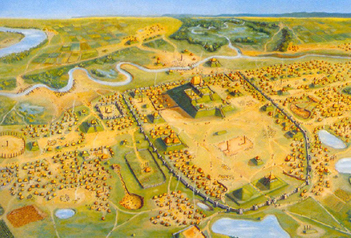
Cahokia is the name given to an Indian settlement that exists outside of Collinsville, Illinois. Archeologists estimate that the city was founded sometime around 650 AD, and its complex network of burial grounds and sophisticated landscaping prove that it was once a thriving community. It has been estimated that at its peak the city was home to as many as 40,000 people, which would have made it the most populous settlement in America prior to the arrival of the Europeans. The most notable aspect of Cahokia today are the 80 mounds of earth, some as high as 100 feet, which dot the 2,200-acre site. These helped create a network of plazas throughout the city, and it is believed that important buildings, like the home of the settlement's chief, were built on top of them. The site also features a series of wooden posts that archeologists have dubbed "woodhenge." The posts are said to mark the solstices and equinoxes, and supposedly figured prominently in the community's astronomical mythology.
卡霍基亚,是由现存于伊利诺伊州,科林斯维尔之外的印第安人部落命名的。据历史学家估计,这座城市大约发现于公元650年,其复杂的墓地布局和精美的园林设计都证明这里曾一度是个繁荣的部落。城市的鼎盛时期,约有4万人在此安家,在欧洲人到来之前,这一度成为人口最密集的地区。如今的卡霍基亚最值得注意的地方就是地表80个土丘,一些有100英尺高,占地2200英亩。这些土丘创建了贯穿整座城市的市场网络。有人认为,重要的建筑物——酋长的家——会建于它们的顶部。这处遗址同样以一连串的木桩为特色,历史学家称之为"史前栏杆"。据说这些木桩是用来标记二至点和二分点的,又或许它们已经准确地刻画出了部落的文学神话。
The Mystery:Although scientists are constantly discovering new information about the Cohokia community, the biggest mystery that remains is which modern Indian tribe is descended from the residents of the ancient city, as well as just what it was that caused them to abandon their settlement.
谜团:虽然科学家们不停地发掘出卡霍基亚部落的最新信息,但遗留至今的最大谜团仍有2个——现今的印第安部落到底哪一个是古代城市居民的后裔?到底是什么原因导致他们放弃了居住地?
9.Newgrange
9.纽格莱奇墓
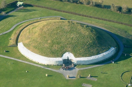
Considered to be the oldest and most famous prehistoric site in all of Ireland, Newgrange is a tomb that was built from earth, wood, clay, and stone around 3100 BC, some 1000 years before the construction of the pyramids in Egypt. It consists of a long passage that leads to a cross-shaped chamber that was apparently used as a tomb, as it contains stone basins filled with cremated remains. The most unique feature of Newgrange is its careful and sturdy design, which has helped the structure remain completely waterproof to this day. Most amazing of all, the entrance to the tomb was positioned relative to the sun in such a way that on the winter solstice, the shortest day of the year, the rays from the sun are channeled through the opening and down the nearly 60 foot passageway, where they illuminate the floor of the monument's central room.
纽格莱奇墓被视为爱尔兰最古老最著名的史前遗址。它是一个由泥土、木材、黏土和石头建造的坟墓,建造于公元前3100年前,比埃及金字塔还早了1000年。它内含一条长通道,通向一间十字形房间,里面有一个盛满骨灰的石盆,显然是被用作墓室。纽格莱奇墓最大的特点是它精巧而坚固的设计,使墓室直到现在还能完全防水。最奇特的是,冬至时,阳光可以从墓室入口的上方天窗照射进来,布满将近60英尺的通道,照亮古迹中的中心房间。
The Mystery:Archeologists know Newgrange was used as a tomb, but why and for who still remains a mystery. The painstaking design needed to guarantee that the yearly solstice event occurs suggests that the site was held in high regard, but other than the obvious hypothesis that the sun featured prominently in the mythology of the builders, scientists are at a loss to describe the true reason for Newgrange's construction.
谜团:历史学家们知道纽格莱奇墓曾用做墓室,但为谁所用,为何而建仍旧是个谜团。为了确保每年冬至日出现奇观,需要高难度的设计,表明建造过程中墓室受到了高度重视。除了对建筑师所刻画出的,神话中的太阳,有明显的假设,科学家们依旧对纽格莱奇墓建造的真正原因困惑不解。
8.The Yonaguni Monument
8.与那国岛遗址
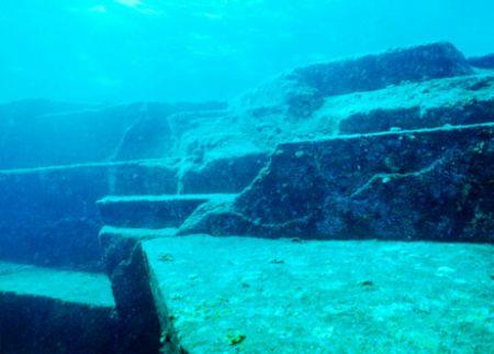
Of all the famous monuments in Japan, perhaps none is more perplexing than Yonaguni, an underwater rock formation that lies off the coast of the Ryuku Islands. It was discovered in 1987 by a group of divers who were there to observe Hammerhead sharks, and it immediately sparked a huge amount of debate in the Japanese scientific community. The monument is made up of a series of striking rock formations including massive platforms, carved steps, and huge stone pillars that lie at depths of 5-40 meters. There is a triangular formation that has become known as "the turtle" for its unique shape, as well as a long, straight wall that borders one of the larger platforms. The currents in the area are known for being particularly treacherous, but this has not stopped the Yonaguni monument from becoming one of the most popular diving locations in all of Japan.
日本著名的遗址中,没有一个像与那国岛的遗址那样令人费解——一个位于琉球群岛海岸下的岩层。它于1987年被观察锤头鲨的潜水队发现,很快引发了日本科学界的众多争论。遗迹位于海渊5-40米处,由巨大的岩层组成,包括巨大的平台,雕有花纹的台阶和巨大的石柱。遗迹中有一个三角形的构造,因其独特的海龟造型而为人所知。同样的深度,有一个巨大的平台,与之相邻的是一堵竖墙。即便这片地方被认为是危险区域,但仍旧是日本最受欢迎的潜水地之一。
The Mystery:The ongoing debate surrounding Yonaguni centers on one key subject: is the monument a natural phenomenon, or is it man-made? Scientists have long argued that millennia of strong currents and erosion have carved the formations out of the ocean floor, and they point to the fact that the monument is all one piece of solid rock as proof that it was not assembled by a builder. Others, though, point to the many straight edges, square corners and 90-degree angles of the formation as proof that it's artificial. They often cite one formation in particular, a section of rock that resembles a crude carving of a human face, as evidence. If they are right, then an even more interesting mystery presents itself: who constructed the Yonaguni Monument, and for what purpose?
谜团:无休止的争论都围绕一个重要主题——这个遗迹是自然现象还是人为建造?科学家们进行了长久的争论,一些人认为是水流的冲刷和腐蚀使海平面上的结构发生改变,他们还指出,这些遗迹均由一片岩层构成,并不是建造者组装得到的。另一些人则认为,这些直边、尖角和结构上的90度角度都证实是人为建造的。他们经常用一个特殊的形状作为例子——一个岩石的截面像是用原油雕刻出的人脸。如果假设是正确的,那么更有趣的谜团出现了——是谁建造的与那国岛海底地形?到底是出于何种目的?
7.The Nazca Lines
7.纳斯卡线条
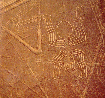
The Nazca lines are a series of designs and pictographs carved into the ground in the Nazca Desert, a dry plateau located in Peru. They cover an area of some 50 miles, and were supposedly created between 200 BC and 700 AD by the Nazca Indians, who designed them by scraping away the copper colored rocks of the desert floor to expose the lighter-colored earth beneath. The lines have managed to remain intact for hundreds of years thanks to the region's arid climate, which sees it receive little rain or wind throughout the year. Some of the lines span distances of 600 feet, and they depict everything from simple designs and shapes to characterizations of plants, insects, and animals.
纳斯卡线条是由一系列的图案和象形文字组成的,刻画在秘鲁干燥高原上的纳斯卡荒原上,覆盖了约50英里的地域。据推测,它在公元前200年到公元700年由纳斯卡印第安人创建,他们刮除荒原上深铜色的岩石表面,露出下方浅色的地表来表现图案,这些图案被干燥、少雨、少风的气候完整地保存了百年。一些线的间隔长度达到600尺。建造者们用简洁的设计来表示一切,并且用图案来表现昆虫和动物的特性。
The Mystery:Scientists know who made the Nazca Lines and how they did it, but they still don't know why. The most popular and reasonable hypothesis is that the lines must have figured in the Nazca people's religious beliefs, and that they made the designs as offerings to the gods, who would've been able to see them from the heavens. Still, other scientists argue that the lines are evidence of massive looms that the Nazcas used to make textiles, and one investigator has even made the preposterous claim that they are the remnants of ancient airfields used by a vanished, technologically advanced society.
谜团:科学家们知道是谁画出的纳斯卡线条,并知道它们是怎样做出来的,但是仍旧不知道为何要画这些图。最普遍也是最合理的假设是这些图案表现出了纳斯卡人的宗教信仰,他们画图案是为了向俯察他们的上帝做祷告。当然,另一些科学家认为,这些线条是纳斯卡人使用大量纺织机纺织过的证据。有一位观察者甚至做过一个可笑论述——纳斯卡是技术先进却已销声匿迹的社会,用过的古代飞机场的遗留物。
6.Goseck Circle
6.戈瑟克圆圈
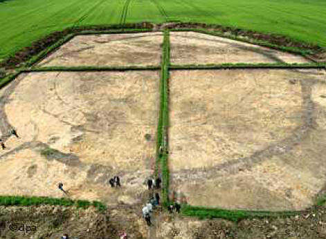
One of the most mysterious landmarks in Germany is the Goseck Circle, a monument made out of earth, gravel, and wooden palisades that is regarded as the earliest example of a primitive "solar observatory." The circle consists of a series of circular ditches surrounded by palisade walls (which have since been reconstructed) that house a raised mound of dirt in the center. The palisades have three openings, or gates, that point southeast, southwest, and north. It is believed that the monument was built around 4900 BC by Neolithic peoples, and that the three openings correspond to the direction from which the sun rises on the winter solstice.
戈瑟克圆圈是德国最神秘的地标,由土壤、碎石和木制栏杆组成,被认为是古老的太阳天文台的最早标志。圆圈由围绕在栏杆墙的一系列环形沟壑组成(已重建),中间有一个土堆,栏杆有三个开口或是大门,指向东南、西南和北方。该遗迹由新石器时代的人建于公元前4900年,三个开口都和冬至时太阳升起的方向一致。
The Mystery:The monument's careful construction has led many scientists to believe that the Goseck Circle was built to serve as some kind of primitive solar or lunar calendar, but its exact use is still a source of debate. Evidence has shown that a so-called "solar cult" was widespread in ancient Europe. This has led to speculation that the Circle was used in some kind of ritual, perhaps even in conjunction with human sacrifice. This hypothesis has yet to be proven, but archeologists have uncovered several human bones, including a headless skeleton, just outside the palisade walls.
谜团:遗迹精巧的构造使科学家们相信戈瑟克圆圈被用于指导农业活动,但是它真实的用途仍旧是争论的源头。证据表明所谓的"太阳祭祀"在古欧洲广为流传,同时也引发了一种推测——这些圆圈曾用于部分祭祀,甚至和活人祭祀一同使用。这种假设有待证明,但历史学家们发掘出几个人类遗骨,包括在栅栏墙之外的无头骨架。
翻译:漫小飒 来源:前十网


