(单词翻译:单击)
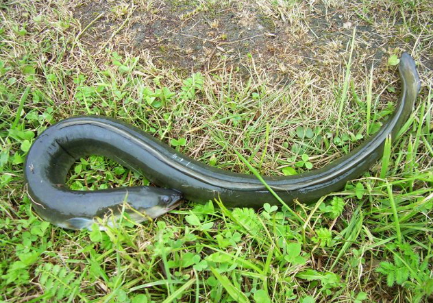
3.Anguilla Eels Can Walk On Land
3.安圭拉鳗能在陆地上行走
Anguilla eels, commonly known as European eels, live in the lakes and waterways of northern Europe and the UK. They've been recorded at lengths of nearly 2 meters (6.5 ft), though they're normally only about half that size or smaller. But they don't always stay where they're supposed to—Anguilla eels can leave the water and slither across dry land for a short amount of time. They do this for two reasons—the first is to feed, although they usually stick to insects and earthworms. The second reason is to migrate.
安圭拉鳗一般称作欧洲鳗,生活在北欧和英国的湖泊、航道中。根据记录,它们有近2米(6.5英尺)长,尽管一般的要小一半或者更小。但是它们并不总是待在人们认为它们应该待的地方——安圭拉鳗能离开水体,短时间内滑过干燥的陆地。它们这样做有两个原因:其一是取食,尽管它们通常吃昆虫和蚯蚓;其二是迁徙。

Anguilla eels spend about 20 years in the same lake. But they start and end their lives 6,500 kilometers (4,000 mi) across the Atlantic in the Sargasso Sea. To get from their European lakes to the Atlantic, anguillas work their way up and down waterways using an as-yet-undiscovered navigation system. If the waterway is blocked—with a dam, for example—the eels leave the water and cross fields and forests to the next stream or river. Environmentalists are actually using that unique ability to build climbable "ladders" on dams and weirs to allow the eels to complete their migrations. On a slightly more terrifying note, the larger cousins of anguillas, conger eels, can also cross dry land, and also have the tendency to attack people.
安圭拉鳗能在同一个湖泊里待上20年左右。但是它们生命的开始和结束却要跨越大西洋,在6500千米(4000米)之外的马尾藻海里。为了从欧洲的湖泊到达大西洋,安圭拉鳗借助各条航道完成自己的旅程——它们使用什么样的导航系统我们还不知晓。如果航道堵塞——比如有水坝——这些鳗会离开水体,穿过田野和森林到达下一条小溪或小河。环境学家就运用它们这种独特的能力在水坝上修建了"梯子",让它们爬过去,完成迁徙。有一点比较吓人,安圭拉鳗的亲戚,康吉鳗也能穿过干燥的陆地,并对人类也具有攻击性。
2.The World's Largest Migration Happens Every Day
2.世界上规模最大迁徙每天都在进行

The Sargasso Sea is perhaps the most unique body of water in the world. It doesn't have any borders other than a series of converging currents that hold it roughly in the same place, even though it's right in the middle of the Atlantic Ocean. It's a body of water within a body of water—the Gulf Stream, the North Atlantic Current, and the Canary Current all hit it on different sides, with the Sargasso Sea acting as the calm center. It was called the "Sea of Lost Ships" by sailors because the air is unnaturally calm and ships could get stuck there for days or weeks.
马尾藻海应该是世界上最具特色的水体了。它没有什么边界,只有一系列汇聚到一起的洋流可以大概确定它的位置,即使它就在大西洋中间。这是一片水域之中的一部分——湾流、北大西洋暖流、加那利洋流都从不同方向汇聚其中,马尾藻海扮演着平静的中心的角色。它被水手称为"迷船之海",因为气流异常平静,船只可能被困上几天或几个星期。
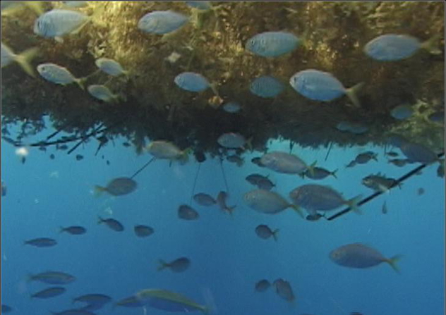
Most importantly, the Sargasso Sea is an almost completely self-sufficient ecosystem. The sargassum, a floating seaweed that covers the surface of the sea, provides food and shelter for thousands of species, which in turn provide food for the sargassum through their waste. There are layers upon layers of marine life in the sea, from surface dwellers to deep-sea life over 5000 meters (16,000 ft) down. And at night, it's the setting for the largest migration in the world—over 5,000 species comprising millions of sea creatures surge up from the deep to feed, then return to the bottom before dawn.
更重要的是,马尾藻海几乎是一个完全自给自足的生态体系。果囊马尾藻是一种漂浮在洋面上的海藻,为成千上万种生物提供食物和庇护,动物的排泄物也反过来为海藻提供养料。海里的生物一层叠一层,从海面直到深海超过5000米(16000英尺)。晚上,这里就是世界上最大规模迁徙的舞台——5000多种生物,总共几百万海洋生物,从深海突然出现,寻找食物,黎明前再回到海底。
1.Google Street View: Oceans
1.谷歌街景:海洋

Google Street View is a popular addition to Google Maps that lets you look at any location from street level. In 2007, Google sent a fleet of cars around the world to photograph literally everything. Then they took the photos and composited them into a long string that lets you "walk" any route with the click of a button. But that's old news and hardly exciting.
谷歌街景是谷歌地图的很受欢迎的附加功能,让你能用在街上的角度看任何地点。2007年,谷歌在全世界派出一支车队,为一切东西照相。然后他们将照片合成一长串,让你点击一个按钮就能"走"任何路线。但是这已经不是新闻了,不值得兴奋。
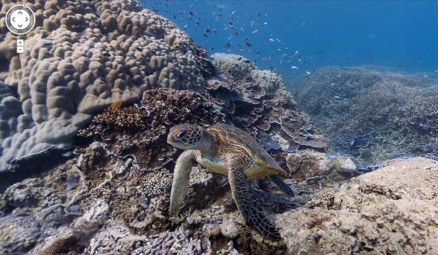
Street View: Oceans is sort of the same thing, except instead of looking at your ex-girlfriend's house you can stroll directly into the Great Barrier Reef, or any one of dozens of underwater spots spread across six oceans. They're adding more locations to the program as fast as they can, but so far they only have the reefs around the Galapagos Islands, Heron Island, Wilson Island, and Hanauma Bay, to name a few. This is part publicity stunt and part science project—while anyone can enjoy the tour, they're also using the photos to monitor the growth (and decay) of the world's most important coral reefs, which provide a combined home for a full 25 percent of all marine life.
街景:海洋也与此类似,除了你看不见前女友的房子,取而代之,你能直接在大堡礁里散步,或者走进六大洋几十个水下景点的任何一个。他们正全速增加这个应用里的位置,但是目前为止为数不多,只有加拉帕戈斯群岛、苍鹭岛、威尔逊岛和恐龙湾等附近的珊瑚。这一部分是公众信息特技,一部分是科学项目——当人人都可以享受这样的旅行时,他们也在用相片监管世界最重要的珊瑚的生长(和腐坏)情况,这些珊瑚是整整25%的海洋生命的大家庭。
翻译:罗惠月 来源:前十网


