(单词翻译:单击)
The phrase "lost continent" always makes me wonder, how exactly does one "lose" a whole continent?
“失落的大陆”,这个词总会让我好奇,整个的大陆究竟是怎么“失去”的?
Like, where did it go?
比如,它究竟去了哪里?
Scientists have spent nearly 10 years piecing this together:
科学家们花了将近10年的时间才把这一问题的答案拼凑起来,
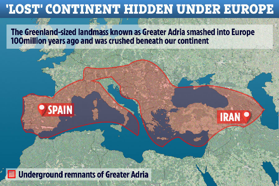
a frame-by-frame breakdown of 240 million years of history to give us a picture of a lost continent they're calling Greater Adria.
他们逐帧逐帧地分析了2.4亿年的历史,就为了给我们呈现出所谓“大阿德里亚”大陆失落的来龙去脉。
And, it turns out, it's not truly gone…it's underneath us.
事实表明,这块大陆并没有真正消失……而是跑到我们下面去了。
Well, mostly underneath southern Europe.
嗯,准确地说,是大部分都跑到南欧下面了。
But let's go back to the beginning.
我们还是从头说起吧。
About 240 million years ago, this Greenland-sized land mass was part of the Gondwana supercontinent,
大约2.4亿年前,这块格陵兰岛大小的陆块还是冈瓦纳古陆的一部分,
wedged in with its North African and European counterparts.
与北非大陆和欧洲大陆是兄弟大陆。
About 20 million years later,
大约2000万年后,
it decided to make a break for it and started separating from Africa,
它决定单飞,开始脱离非洲大陆了,
and in another 40 million years it became a truly independent continent.
又过了4000万年,它终于成了实实在在的独立大陆。
We don"t know a whole lot about what it was like,
我们并不十分清楚脱离的具体过程,
but researchers are pretty sure it was largely submerged,
但研究者们颇为肯定地认为这块大陆的大部分地区都被淹没了,
maybe with some bits sticking up here and there.
偶尔有这儿一块那儿一块还露在上面。
This is because they"ve found that for most of history, almost all of it was covered in marine sediments.
这也是为什么研究者们会发现,这块大陆在它存在的大部分时间里,几乎都是被海洋沉积物覆盖着的原因。
Until about 100 million years ago, that is, when it started to go "crunch".
直到大约1亿万年前,也就是,它开始“摊牌”的时候。
On its journey towards self discovery, floating about on the Earth's surface thanks to continental drift,
在自我发现的道路上,大亚德里亚在地球表面漂啊漂,漂啊漂,
Greater Adria encountered what is now southern Europe.
漂着漂着就漂到了南欧边儿上。
And when tectonic plates encounter each other, one plate has to go under the other, which is called subduction.
两个构造板块相遇时,一个板块必须从另一个板块下方穿过,也就是所谓的“潜没”。
This process can be relatively short,
有时,这一过程耗时较短,
where one plate doesn't go very far under the other, or one continent can be totally subsumed by the other.
因为下去的那个板块下降得并不是很深,而有时,下去的那个板块会被上面的那个完全覆盖掉。
This process of continental collision often smooshes the plates up to form mountains, like the Himalayas.
大陆板块碰撞的这种过程通常会使板块拱起来变成大山,喜马拉雅山就是这么形成的。
In the case of Greater Adria, it meets southern Europe
就大亚德里亚大陆而言,它碰上了南欧,
and it shatters into pieces and is sucked under its opposing continental plate,
被撞得稀碎后又被吸附到了对面南欧大陆的下面,
where it gets officially "lost" in Earth's syrupy mantle.
由此,它便正式从地球糖浆状的地幔里“消失”了。
But as it goes, its top layer gets scraped off and shoved up, instead of down,
不过,随着它的移动,它的表层被南欧大陆削掉又被挤凸出来了,并没有被挤凹下去,
forming part of the Apennine mountains in central Italy.
变成了意大利中部的亚平宁山脉的一部分。
This is how we get marine fossils on top of mountains—
我们在山顶上看到的海洋化石就是这么来的——
those marine sediment layers on the top of a continent like Greater Adria
大阿德里亚这种大陆上面的这些海洋沉积层
gets scraped off during subduction and carried upward by mountain formation.
会在潜没的过程中被刮掉,接着又在山脉形成的过程中被推上来。
Colliding plates are a messy and chaotic business,
板块碰撞的过程是比较混乱的,
and these relics of a lost continent, mostly chunks of limestone, are sprinkled all over the Mediterranean.
失落大陆的这些遗迹,大部分都变成了大块大块的石灰岩散布在了地中海各处。
This means the continental remnants are spread out across borders.
这就意味着失落大陆的遗迹会跨越国界而存在。
Geoscience agencies tend to have developed their own logic and ways of talking about these kinds of geological processes,
地球科学机构往往都有自己的一套逻辑和方法来讨论这些地质过程,
so piecing all of it together to form a whole picture was challenging in ways even beyond the science.
也就是说,将所有这些拼凑成一个完整的图景不止是一个科学难题。
These hurdles were partly why this data took so long to amass,
一定程度而言,科学家们之所以花了这么久才得出上述数据也是因为存在这些障碍。
but also just because of the sheer number of pieces of the continent there were to puzzle together.
还有就是需要拼凑的板块碎片实在是太多了。
Each sample of rock from this continent—its size, shape, composition—is its own data point,
这个大陆的每一个岩石样本——大小、形状、组成——都是这个大陆的一个数据点,

and from there the researchers could reverse-engineer the path of the continent as it met its demise.
有了这些数据点,研究者们才能逆向追溯板块终结的历史。
Because even though what we're talking about sounds quite cataclysmic and violent,
因为尽管我们讨论的内容听上去很像是一场灾难,听上去很剧烈,
all of this motion is happening over tens of millions of years.
事实上,整个过程其实经历了数千万年的时间。
So when the researchers say they think that Greater Adria spun counterclockwise as it subducted down into the depths,
研究人员们说,他们认为大阿德里亚大陆潜没的时候是逆时针旋转的,
we're talking about 3-4 centimeters per year rate of change in position.
那我们讨论的其实是一年才走了3~4cm这样的一个潜没节奏。
And there's other exciting work that's excavating evidence of lost continents!
令人激动的是,研究者们还发现了其他有关失落大陆的证据!
This same research team has also used seismic waves to pulse the mantle to generate an image,
该研究小组还用到了利用地震波激发地幔成像的技术,
a little bit like a medical imaging scan, to see what's hanging out in the Earth's mantle.
跟医学成像扫描有点儿像,试图弄清地幔的成分。
They are creating what they like to call "an atlas of the underworld",
他们正在创建他们所谓的“地下世界地图集”,
or the first complete mapping of subducted tectonic plates that have ended up in the Earth's mantle.
届时,他们绘制出的就是首个最终进入地幔的潜没的构造板块的地图。
Using these methods, they've seen evidence of Greater Adria up to 1500 km below the surface of the Earth.
通过这些手段,研究人员已经找到了证据,表明大阿德里亚古陆潜没的深度可能达到了1500km。
"Deep stuff."
“好深(奥)啊”!
If you want more on crazy cool things lurking below Earth's crust, check out this video here,
想了解更多隐藏在地壳下的神奇科学,那就请看这段视频,
and make sure you subscribe to Seeker for all of your groundbreaking geoscience discoveries!
记得订阅我们的频道,了解所有突破性的地球科学发现!
Thanks so much for watching, and I'll see you next time.
感谢大家的收看,我们下次节目再见。


